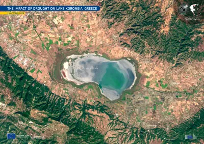
nature & planetCopernicus Image of the Day1984–2016 · Lake Koroneia, northern Greece
Lake Koroneia in Greece has shrunk to about 6% of its 1984 size
Lake Koroneia, a protected wetland northeast of Thessaloniki in northern Greece, was once the country's fifth-largest lake. According to the National Observatory of Athens, its surface area fell from 42.8 square kilometers in 1984 to 34.4 square kilometers in 2016, and to about 2.7 square kilometers in 2026. That is roughly 6% of its 1984 extent. Satellite imagery from Copernicus shows how far the lake has receded over four decades.
The shrinking lake shows how a protected wetland can nearly disappear over four decades, with consequences for the birds and communities that depend on it.
background
Lake Koroneia (Greek: Λίμνη Κορώνεια) is a lake in the heart of the Thessaloniki regional unit in the Mygdonian basin in Greece. It is also known as Lake Agios Vasileios after the village Agios Vasileios and as Lake Langadas after the town Langadas, and is located about 14 kilometres east of Thessaloniki city centre. The A2 motorway (Egnatia Odos) passes along the north side of the lake, and the old Greek National Road 2 passes along the south side. The lake is shared by the municipalities Langadas and Volvi.
From Wikipedia: Lake Koroneia (CC BY-SA 4.0) ↗see


key facts
- Country
- Greece
- Located in
- Lagkadas Municipality
- Area
- 43 km²
- Elevation
- 75 m
Facts: Wikidata (CC0)
European Union, Copernicus Sentinel-2 imagery · CC BY 4.0

